


Pont de mont vert

fb30
User

Length
100 km

Max alt
1192 m

Uphill gradient
1164 m
Km-Effort
119 km

Min alt
60 m

Downhill gradient
2228 m
Boucle
No
Creation date :
2019-10-26 09:36:00.0
Updated on :
2019-10-26 15:44:25.342
1h25
Difficulty : Difficult

FREE GPS app for hiking
 SityTrail
IGN / Geographical institutes
SityTrail Plus
The world is yours!
About
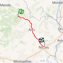
Trail Walking of 100 km to be discovered at Occitania, Lozère, Pont de Montvert - Sud Mont Lozère. This trail is proposed by fb30.
Description
Rando
Positioning
Country:
France
Region :
Occitania
Department/Province :
Lozère
Municipality :
Pont de Montvert - Sud Mont Lozère
Location:
Saint-Maurice-de-Ventalon
Start:(Dec)
Start:(UTM)
562217 ; 4907978 (31T) N.
Comments